![]()
![]()
|
By the middle of the seventeenth century,
the colonists could turn from the struggle to survive to the serious
business of establishing their own social and economic system along
the navigable river, now freed from the Indian threat. For a time they
accepted the natural upper boundary of rocks at the Fall Line, and built
their houses, first of wood and then of brick, along the curves of the
lower James. What resulted was a linear structuring of class and wealth
strung along the region they called the Tidewater, a name signifying
the centrality of the river in their lives.
The most enterprising newcomers gradually
secured large grants stretched along the more fertile soil close to
the river, often by using the land rights, called headrights, of the
poorer emigrants and indentured servants they had transported. There
they established plantations, and as servants completed their indentures,
the planters turned increasingly to slaves for the cheap labor needed
to grow as much tobacco as possible and quickly, since this crop exhausted
the soil in a fairly short time. Soon the river had taken on its nickname,
the "old muddy Jeems," as the red dirt increasingly eroded. But they
did more than break up the soil. Since the major highway was the sometimes
unpredictable river, planters soon found it useful to have virtually
every kind of craftsman available on their land. Each large plantation,
then, became a fairly self-sufficient settlement under one management,
linked by its boats and wharves with other similar plantations, and
particularly with England.
Back from the river far beyond the choicer
soils were white people who had more trouble eking out an independent
living, the yeoman farmers, many of whom were once indentured servants.
By the eighteenth century, access to the river was generally denied
to them, so they also had little access to the wealth being shipped
on the water. Crops for the profitable export trade usually had to be
sold through the nearest plantation owner with a wharf. Many of the
more enterprising farmers, especially south of the river, eventually
gave up and went to North Carolina to be free of the power of the river
barons.
People with the privilege of living on
the river had a decided advantage, in spite of the occasional danger
of floods. On the river banks were to be found the cooling summer breezes,
the easy fishing, and more fertile acreage, but particularly a front
row seat on the colony and the world. The river was swarming with boats
and ships of all descriptions by the eighteenth century, many built
right on the plantations from their own forests. Indeed, some of the
earliest plantation owners had first been shipwrights and sailors and
were still unwilling to venture far from the water which had given them
a good livelihood. They benefited from the many ways England encouraged
shipbuilding (in response to her own lack of timber), exempting Virginia-made
ships from duties and pushing the emigration of shipbuilders. By the
time the British shipbuilding industry began demanding protective legislation,
first passed in 1680, it was too late. The colonists kept on building,
now devoting more of the ships to internal use, plying the James, the
Bay, and the West Indies.
For a long time, the native boats on the
James were either versions of the serviceable Indian canoe or shallops,
shorter and with masts, both of which could navigate the creeks and
shallow river stretches with ease. Every owner of riverside land had
at least one, to fish and go oystering, transport tobacco out to larger
ships moored in the channel and bring the goods back, even to attend
the parish church in many cases. By 1648, hundreds of boats were reported
tied up on the James, and many had been built on the river.
By the eighteenth century, much of the
shipbuilding had shifted to public shipyards in seaport towns, especially
Norfolk, but boats, particularly those suited to the river's variable
depths, were still being built on plantations such as Flowerdieu, Westover,
and Berkeley. The variety of these crafts shows how river-dwellers adapted
to the shapes of their rivers and creeks: there were canoes, bateaux,
barges, punts, piraguas, flats, pinnaces, shallops, and sloops. Sloops
were particularly popular, even after England restricted Virginian shipbuilding;
they were built in the colony, filled with tobacco, and sold off--complete
with cargo--in the West Indies. Since they had to dodge pirates in the
Bay and the Caribbean, they were developed for speed and maneuverability.
The people with access to boats also had
access to what money could be brought in by the tobacco trade. They
could best afford the treasures of Europe and the Orient brought by
European ships to grace their new mansions. They also supported the
New England ships that carried loads of slaves to work the tobacco fields
and cargoes of rum from the West Indies. Those who lived away from the
river highway had no such opportunities. Ironically, then, the ability
of riparian owners to communicate by boat with each other and the rest
of the world eventually erected considerable barriers of class and wealth
between them and their neighbors.
Yet even with their boats, the widely
separated plantations were probably less connected with each other than
each was with England. The river, with its tides, strong currents, and
unreliable winds, could be a rough highway, especially for smaller boats.
Whenever there was visiting between plantations, people planned to stay
for a while; thus, the famed hospitality was also a necessity. But even
the river-dwelling planters were slow to evolve into a community, especially
as compared with their New England counterparts .
The river made and shaped the fortunes
of many gentlemen in the eighteenth century, but few were as colorful
and articulate as William Byrd II, builder of the manorial Westover.
Like most of the wealthy planters, he inherited much of his land, more
than 25,000 acres including the key river lands above Jamestown and
along the Fall Line, from an industrious father and grandfather who
used politics and indentures freely to acquire property. But he developed
his extravagant tastes, as well as a gentleman's education, in England
where he spent most of his first thirty years as a gallant bachelor.
For a while, the James meant little more to him than a highway link
to England, the center of civilized life. But he came to relish the
role of riparian lord, entertaining lavishly and at length whenever
he was not crossing and exploring up the river, seeking new land grants
and resources to develop, especially metals.
Not the least of the river's gifts which
Byrd praises is its fish life. Byrd lists species at length, spotlighting
the ones which taste best. Sturgeon, he claims, tastes "like the best
veal"; he particularly lauds the abundance of spawning fish, especially
herring, for "it is unbelievable, indeed, indescribable, as also incomprehensible,
what quantity is found there." He seldom found himself at such a loss
for words, but it is, finally, our loss, for it is impossible for us
to visualize today what he saw.
The little book gives testimony that the
river was thoroughly a part, even a center, of the life beside it, contributing
to the wealth of those with access. One wonders about those who could
not benefit from this resource, but that is a world which Byrd knew
little about. Whenever he did encounter people without a river, as in
eastern North Carolina (a place he facetiously named Eden), he is scornful,
finding them lazy and provincial.
But the days of the wealthy planters were
numbered, largely because their sons and grandsons lost interest in
farming the money crop of tobacco at about the same time that the land's
riverborne fertility became exhausted. Byrd himself died in debt, but
it was his son who actually lost much of the river land. An era of concentrated
river wealth soon passed, but not without leaving its divisive mark.
There were other kinds of division enforced
by the river. A look at a map shows that rivers have always been natural
boundaries, dividing nations, states, parishes, and neighbors of all
sorts, human and animal. No number of bridges, for example, will change
the fact that the Mississippi divides the whole country, not just physically.
What were once rather formidable physical barriers, even though penetrated
by ferries and bridges, often linger to mark cultural and psychological
boundaries today.
The James very nearly splits the state
of Virginia in half, zigzagging from its headwater springs northwest
in the mountains near what is now west Virginia to the southeast corner
of the Chesapeake Bay. As long as the river was used as a highway in
the thick wilderness, however, people stayed close beside it and north
was rarely divided from south. The Indian confederacies above and below
the Fall Line paid little mind to the river as a boundary. Tribes like
the Weyanoke and the Monacans established villages on both sides. The
Fall Line rapids and the mountains did raise serious barriers, but not
the river itself. Perhaps it was so much at the center of the Indians'
lives, especially during the fish runs, that it could not be easily
perceived as dividing.
That unity was threatened when Jamestown--and
eventually the entire north side of the river--was chosen to be the
hub of the new colony. Even after most settlers, including governors,
chose not to brave the legendary Jamestown sicknesses, its place of
preeminence in the colony was assured by its busy wharf, first on the
Back River and then, when that filled up, on the deep water of the river
curve where ships could be moored to the trees. For many years, every
European ship coming up the rivers of Virginia to trade had to stop
first to register at Jamestown. Naturally, many simply chose to load
and unload their goods there, thus making Jamestown an economic center.
For easier access, by road if necessary, both to the assembly and the
trade, official institutions such as courthouses and churches of the
counties and parishes that stretched across the river and even the College
of William and Mary were set on the north side. When Jamestown was finally
abandoned at the end of the seventeenth century, the capital moved only
a few miles north to Williamsburg. No one evidently even considered
a south side location. This division proved to be irreversible.
It took little time for the southsiders
to begin developing a different sort of culture, one centered more on
farming and raising hogs than on politics. Their major early contribution
was the use of marl as fertilizer, and not the production of political
pamphlets, even during the Revolution. Wealth and power were increasingly
concentrated on the north side, especially after roads were cut to connect
plantations on the many navigable rivers above the James.
There are different ways to measure this
growing domination of the north side of the tidewater James, but my
yardstick is a family one. In 1608 Captain John Woodlief came to Jamestown,
learned how to survive, and returned to England to gather his family
and indentured servants. Selected to be governor of a settlement above
Jamestown on an 8,000-acre site named the Berkeley
Hundred, he brought a shipload of new colonists late in 1619. Upon
arrival, he conducted what Virginians now proudly cite as the first
Thanksgiving service. As often happened in the colonies, Woodlief's
ability to produce profits for his financial backers came in question
and he was fired, so he moved south to land along Bailey's Creek and
the river near present-day Hopewell.
Meanwhile, Benjamin Harrison settled in
Surry County, right across the river from Jamestown. He prospered as
a tobacco planter, leaving wealth that enabled his grandson to purchase
the Berkeley Hundred, thereby moving into the circles of colonial power
on the north bank. His son, Benjamin Harrison IV, married the daughter
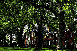
of wealthy planter King Carter and built the manorial house next door
to William Byrd's Westover, beginning his dynasty there. Struck down
by lightning, he left Berkeley and its wealth to his son Benjamin, freeing
him to become a prominent colonial statesman, first as a burgess and
eventually as a member of the Continental Congress and signer of the
Declaration of Independence. In turn, the "signer's" youngest son William
Henry and great grandson Benjamin were both to become Presidents of
the United States after they had left Virginia for the more promising
West. The house still stands as a symbol of a Virginia plantation dynasty,
with its vanishing claims to aristocracy.
Captain Woodlief"s descendents across
the river, by contrast, are almost erased from history, having continuously
but obscurely farmed their river land until it was lost in the Civil
War. Younger sons migrated not to the centers of power at Jamestown,
Williamsburg, or even Richmond, but primarily to southeastern North
Carolina, looking for more fertile soil. They were never baronial planters
or political leaders, but many were reasonably successful farmers, respected
and influential in their rural communities south of the James.
The growing division in interests and
prestige between the two banks of the river grew, especially as connecting
roads were cut on each side. The developing split can be mapped in Charles
City County, just above Jamestown, which originally stretched south
of the river from the North Carolina line to the Appalachians and north
to the York River. By 1655, Francis
Lutz writes, "inhabitants of the sprawling territory south of the
great natural barrier saw no reason why they should be compelled to
travel a long distance, including the crossing of a turbulent stream,
to attend church and county court sessions." They resented the periodic
militia musters on the north side, but not as much as did north side
residents who feared they might be called on to "protect the distant
frontiers."
People did not accept the river as a political
barrier without a struggle, however. The General Assembly regularly
mandated public toll ferries, to be regulated by the counties, to promote
unity within the colony. Convenience was another reason for ferries,
but trade itself was little affected, being more oriented to the big
ships in the river channel which served boats from both sides. In 1705
there were twenty public ferries operating on the tidewater James and
its main branches; by 1748 there were thirteen more.
In spite of the ferries, the river remained
a formidable physical boundary. Most ferries could not operate with
any regularity, especially without motors, on a river with strong tides
and currents. Also, ferry owners were entitled to build ordinaries,
or taverns, to put up "travelers, who, on many occasions were unable
to cross the stream for days because of storm and high waters." Since
the ferry owner could make far more money at his tavern than with the
low tolls, he had little incentive to keep his boat moving on schedule.
Charles City County, like the other counties spanning the river, first
divided the parish, since church attendance was considered crucial,
and in 1703 completed total political division, splitting off Prince
George County to the south.
This division of tidewater society became
more pronounced in the nineteenth century, especially after the Confederacy
died. As Parke
Rouse puts it, "Below the James lies Dixie." Southside Virginia
has remained relatively poor and uninfluential; the growing of peanuts,
pine, tobacco, and hams has brought little profit and less power. The
area has a high percentage of Afro-Americans, yet it is also a strong-
hold of white Anglo-Saxon Protestant laborers and of fervent conservatism."
"Southside" has retained a character which some denigrate as "redneck
fundamentalism" and Rouse calls "stubborn, old-fashioned, slow-paced,
insular, ready to fight at the drop of a hat." All seem to agree that
in many respects it is far more like the deep South than the north side
is. The division of Virginians initiated by the river still lingers,
though it is slowly yielding to bridges and the wealth promised by new
industry.
Maps can show how the river has physically
woven its pattern through the landscape, both uniting and dividing its
banks. But the social patterns the river has inadvertently encouraged
and shaped from the beginning are more subtle, though almost as persistent.
The reality of the river plantations and their stratified society has
turned into a myth, cherished by tourists nostalgic for what seems to
be a more ordered life. As they look out over the green lawns on the
north bank, they see only the placid surface of the broad, muddy water.
Since they look from land and not the river, they miss seeing how this
powerful and sometimes disorderly river helped shape that order as it
did the land. The early struggle to adapt a society to the river is
as hidden as the currents and tides which push against upstream travel
and slowly shift soil from one bank to the other.
|