![]()
![]()
|
Once Americans had mastered so many
ways to take advantage of the flow of their rivers, tightening the bond
of dependency, the next task seemed obvious: the water level must be controlled.
Any concerns about water quality were answered with the pat phrase--"Dilution
is the solution to pollution." Ideally, the river would be kept within reasonable
boundaries, neither excessively high nor low but consistently high enough
to flush out waste and heat and keep clear a deep navigational channel.
However, this ideal was suited to people more than to a river whose dimensions
must accommodate whatever rain falls in its basin and the soil it carries.
Unable to control the weather, Americans after World War I chose to try
modifying the weather's effects, primarily by altering the shape and courses
of rivers. It did not seem to matter if some of a river's natural processes
had to be tampered with, as long as the river could be forced to behave
itself. The possibility of controlling pollution at its sources rather than
trying to keep the water level high did not appear feasible at the time.
Since rivers often transgress state boundaries as well as their own beds,
the only organization with the expertise, the money, and the political
power to do the job of controlling rivers, as a rule, was the U.S. Army
Corps of Engineers. Ironically, military engineers appeared to be the
most appropriate managers of unruly rivers. For more than fifty years
of pork-barrel politics, mostly in peacetime, the Corps has patriotically
kept up the struggle with what it has declared to be the "greatest enemy"
of American progress, the major rivers. It has applied American ingenuity
by constructing dams and canals, channelizing, dredging, in short, doing
whatever seems to make rivers more amenable. The spirit of the colonists
whose vision of the river was intertwined with their dreams of wealth
has thrived in this twentieth-century incarnation, for the Corps repeatedly
argues that rivers are the literal bloodstream of the American economy.
Thus, no one could seriously question the need to pour tax dollars into
projects to keep those rivers within human boundaries. No one did either,
until fairly recently.
The best handiwork of the Corps can be seen on the nation's largest rivers,
especially the Mississippi and its large tributaries. Here is an array
of dams, levees, and other creations of concrete and rock, as well as
a fleet of dredging vessels constantly rearranging the silt on the river
bottom. The temperamental river that tested Mark Twain's skills as a cub
pilot has been leashed, though it is still not quite tamed. There are
many who fear that some of the Mississippi's extensive "improvements"
may soon backfire, that long-term and unforeseen consequences are capable
of becoming short- term terrors. The victor in the continuing battle between
the Corps and American rivers has not yet been declared, in spite of the
Corps' detailed cost-benefit ratio computations.
The first attempt to tame the James had been part of an earlier military
strategy, when General Butler's Yankee engineers attempted to blast through
the peninsula at Dutch Gap in 1865. Clearing the loosened dirt out of
the cut after the war was over was simple enough, and many applauded the
convenience of the shorter, straighter navigation route. There have been
consequences, though, for the cut-off portion of the river began filling
up with silt until the only evidence of the former bend today is a swamp
and a "gut" into which heated waters of a coal-fired electric power plant
are discharged. Another pattern had been confirmed on the river: first,
change the river for human convenience and later, find ways to deal with,
even to take advantage of, the unpredicted consequences of those changes.
Although the Corps has had its hand in the reshaping of the James, it
has been more a finger than a fist. In the 1930s it continued the straightening
process by cutting through two more curls, creating two islands. One subsequently
became a wildlife preserve and the other has been mined for its gravel.
So far neither curl has silted up, although the swamp area is increasing
and it is likely only a matter of time. If a closed curl proves to be
a problem (for a sewage treatment plant is scheduled to discharge its
effluent into the flow inside one curve), then the Corps will be asked
to deal with it also, probably by dredging.
The Corps has become quite skilled at dredging the tidewater James, working
constantly to keep at least a 25-foot shipping channel cleared to the
ports below the Fall Line. It has not been an easy task; in 1963 the Corps
had to build a hydraulic model of the James in Vicksburg, Mississippi,
to study the shaping processes peculiar to this river so it can control
them better. The James is still not quite tamed, however. Ocean-going
ships are allowed to negotiate the river only during daylight hours and
under the direction of an experienced pilot, for the channel shifts and
builds up faster than the Corps can clear it. A new problem confronts
the Corps: the sediments shifted by the dredges are increasingly contaminated
by chemicals from industries and land runoff. This one will not be solved
so easily as by building a physical model.
Keeping a channel scooped out is a relatively simple though expensive
operation. Far more challenging is the responsibility the Corps has assumed
for keeping a steady average flow in the river, somewhere between too
much and too little. Few people realize how closely keyed most human uses
of a river are to its average daily flow. Engineers now calculate how
much water will be required to supply cities and irrigate farms, how much
to flush and absorb effluent from sewage treatment plants and heat from
factories and power plants, how much to float large ships, and how much
to turn turbines. In short, they figure how many million gallons a day
are constantly needed to support life, both organic and mechanical, in
and around the river. Then regulatory agencies can permit almost any amount
of development, as long as the total usage requires much less water than
the river usually provides. Ordinarily, this system of water allocation
works, especially since turbines and ships are not too particular about
the quality of water they use.
These averages, though, may reflect some wide and some- times unpredictable
extremes, and therein lies the problem. The average freshwater discharge
of the James is 7,500 cubic feet per second, but extremes have been recorded
as low as 329 cfs and as high as 325,000 cfs. An unusually heavy rain-
fall or snow melt in the basin can turn a dependable flow into an outraging
torrent in a matter of hours. On the James, this can and does happen in
any season in any year. Each generation can count on dealing with three
or four "monster" floods with little warning, interspersed with drought
lows at least once every three years. Planning is further complicated
by the fact that the highest and lowest levels can occur in successive
months in this "flashy" river.
Floods usually get the most attention, but low levels of water, predictable
by season though not by year, can prove to be more annoying and ultimately
more expensive. Reduced water quantity means reduced quality of drinking
water, loss of crops dependent on irrigation, stagnation that chokes fish
life, and shutdown of industries dependent on great quantities of cooling
water. Ironically, the desired increase in flow after rainfall can cause
more problems than it solves as storms flush out the sewers of older cities
and leach chemicals from farmland.
Calculations for water use are now geared to the lowest levels recorded
for the river in a decade to make certain that the minimal flow is clean
enough not to endanger human and fish life or corrode machinery. Thus,
low water, depleted by drought and heat in the basin, translates into
very expensive water treatment facilities which may function at full capacity
for only a few weeks in a dry season. Upriver dams may help augment the
summer flow, but they too are costly. Every gallon of water drawn from
the river when it is at its lowest levels, then, eventually bears an unimaginable
price tag.
The Corps began addressing the problem of periodic low flow levels in
the James in the early 1950s, planning at least three darns on the upper
tributaries which could store water for summer release. This method of
"flow augmentation" was their answer to the increasingly visible water
quality problems below cities; dilution rather than sewage treatment seemed
the cheapest way to reduce the concentration of pollutants. At the time,
Richmond had to divert much of the river's summer flows into canals to
provide drinking water or produce electricity. What was left in the bared
river bed was often largely untreated sewage, which fed thick mats of
algae. Similar water quality problems at Lynchburg prompted its newspaper
to publish a pamphlet in 1949 on "Cleaning the James" which pinpointed
the James' varying streamflow as the chief culprit in water pollution.
Evidently, both the Corps and river residents saw logic in operating the
river on the principles of a flush toilet.
Only one of those three dams has been built, and that was the result
of an extensive campaign by a Chamber of Commerce executive in the upper
basin of the James, Benjamin Moomaw. High in the Allegheny mountains,
near the West Virginia line, was a deep and wild gorge carved by the Jackson
River which had long been a private wildlife preserve. Both Moomaw and
the Corps believed that gorge should be dammed. Meanwhile there were many
obstacles to be hurdled. Twelve miles of trout stream would be eliminated
by the reservoir, as well as countless Indian archaeological sites, but
agreements were eventually worked out with the state agencies concerned.
Finally the Corps was authorized to build an earthen dam at an estimated
cost of $17 million. This became $82 million after extensive caverns were
belatedly discovered on one side of the dam. Tons of concrete had to be
poured and a monitoring system installed to make certain that the dam
would not be undermined. Typically, the Corps chose to try to solve the
problems, and did not consider abandoning the project as unwise. Gathwright
Dam was completed in 1979 and the reservoir began filling .
Like many Corps projects in the country, this one has proved a mixed
blessing, with some empty promises. A number of former Indian sites were
hastily surveyed, just enough to see how many would be submerged. There
was no time for the detailed studies that could have contributed to archaeological
scholarship. The trout population has not fared much better. A new strain
of rainbow trout from Nebraska has recently been stocked in the lake in
hope that they will spawn upstream. Meanwhile, if they do not survive,
the hardier bass, bluegill, and channel catfish which have also been stocked
will probably flourish. Thus, the ecological equation of the stream has
been changed by the dam. There is still a trout stream below the dam,
but landowners there have gone to court to try to keep "outlanders" from
wading in their stream. The case may be decided outside of court, however.
A proposal to retrofit the dam to produce peak electric power, if accepted,
is likely to erode the stream. Whether the sensitive trout, either the
native or the stocked species, can endure all this interference with their
habitat remains to be seen. The argument for flow augmentation once so
loudly touted is now rarely mentioned. No one wants to be reminded that
the reservoir must be kept relatively low behind that earthen dam, just
in case there are more undiscovered caverns. At best, the reservoir can
probably contribute little more than a half inch to the water level at
the Fall Line. However, dilution has become less crucial now that most
of the urban sewage can be treated, not just flushed, and almost no water
has to be diverted out of the river bed.
What is currently advertised is the opportunity that Moomaw Lake offers
for a tourism bonanza in this remote and economically depressed region.
The federal government, however, needs to find another $8 million to build
up the recreation potential. I wonder if this is not another chimera.
When I visited one weekend in the fall of I983, at the height of the famed
leaf color, the picnic tables and boat docks were deserted. To me, the
tall dam looming across the gorge, with water lapping at its foot, looked
like an ugly monument to the great American boondoggle and human inability
to cope with natural processes. Yet the U.S. Army Corps of Engineers still
holds its portfolio of dam projects, and a private organization in the
basin keeps pressing for more dams and reservoirs in the mountains. Farmers
on the Jackson River below the dam are said to be grateful that their
"fences down in the flats" are not "knocked down in the rainy season."
Projects like this make me wonder how the Corps can be so confident about
its ability to calculate all the costs and benefits.
It is not low but high flows--floods, that is--which most arouse public
ire and push the Corps into immediate and drastic actions. After almost
forty relatively quiet years, the James, fed by hurricane-spawned rains,
had the audacity to rise to and above the so-called hundred-year level
twice in three years, in 1969 and 1972. Even though the James floods significantly
on the average of once a decade and the floodplains are clearly marked
on property deeds, and there were 48 to 72 hours of warning, most river
dwellers were unprepared to cope with the generous waters. Few lives were
lost in either flood, but the rhythm of life was temporarily disrupted
and literally disconnected. Arteries of cross-river traffic were blocked
as the waters rose on bridge access roads that dipped into the floodplain
and almost 100 low-lying bridges were broken, tearing downstream with
a few drowned cows to nudge the quaking supports of other bridges. Potable
water supplies stopped after reservoirs and tanks were exhausted and the
streams of electricity and sewage halted as treatment and power plants
on the banks succumbed to the river. Even the chain of water life was
disrupted, as raw sewage and low salinity in the tidewater James destroyed
clams and oysters. Losses for business and homes built in the floodplain
amounted to millions of dollars .
Up and down the river were angry people ready to agree with Ann Bullington's
anthropomorphic description of the flooding James:
This time, however, instead of finding an ally like Benjamin Moomaw,
the Corps encountered an opponent to its post-flood projects. Newton Ancarrow,
a Richmond engineer and boatbuilder, had already spent more than a decade
campaigning against the pollution of the James and photographing its wildflowers.
After the 1972 flood (which had finished off his business), he was appalled
to find that the Corps, funded to clean up after the floods, had brought
in front-end loaders to strip the river islands and banks of debris, as
well as vegetation, trees, and his treasured wildflowers. The next high
water would erode many of these islands into the river, Ancarrow knew,
so there was no time to waste. As a riparian owner, he could take on the
Corps in court. Playing the role of "river nut," using his slides of the
damage and conducting a tour of the river, he won his point despite the
fifteen lawyers and twenty-four expert witnesses brought in by the Corps
and the Justice Department.
The bulldozers were moved away from the Fall Line---but not away from
the river. Since federal funding was still available for "emergency repair
operations," the Corps moved upstream to begin channelizing the tributaries
and the upper James. Here they were more welcome, for residents were still
stunned by the 1969 flood that followed 22 inches of rain in one long
night. But Ancarrow soon discovered what the Corps was doing, and he understood
the environmental damages that could result. This time, since he was not
a riparian owner in the area, he could not go to court, so he resorted
to the camera, hiring professional photographers to fly over and document
how bulldozers were "turning the rivers and streams into drainage ditches."
Using thousands of dollars of his own money, he put together a film called
"The Raging James: An Essay On Channelization."
In the film, eventually shown twice on the public television station,
various experts, standing in front of the scarred riverscape and grinding
bulldozers, testify that sections of these rivers have become biologic
deserts which harbor little or no life. The machines have loosened millions
of tons of soil, sending it downstream to be dredged by the Corps, and
stripped off vegetation, thus increasing the probability of drought damage
and downstream flooding. Every action taken in the basin is shown to have
far-reaching and long-term consequences in the delicate estuary. The point
is made that channelization can be a legitimate way to deal with a river,
but what was happening on the upper James and its tributaries is judged
to be a violent disruption of the river's living processes at an uncalculated
cost.
The Corps completed its work and moved on to other projects, and those
who saw the film were left to wonder about the wisdom of reshaping a river
to control it. There are few ways to measure who won that dispute, and
how much, if anything, the river has actually lost. The Corps still has
not acknowledged defeat in its battle against the flooding river. Its
proposal to build a flood-wall rising thirty feet along the lower banks
of the Fall Line and costing more than $90 million is currently making
its way through Congressional committees. There is no sense of urgency,
for flooding since 1972 has managed to fall within the tolerated limits.
But the Corps keeps watch, waiting for the napping dragon to awaken and
developing new weapons. Meanwhile the Don Quixote who watched the Corps,
Newton Ancarrow, has retired to his home above the Falls.
I too keep an eye on the changing levels of the river, as an apprentice
to an art and not as an expert seeking control. The art of riverwatching
is rooted in a different concept of what makes an ideal river. It disdains
the precise measurements of the mechanical gauges that line the river,
preferring a more inclusive and personal tally which measures both watcher
and watched. Each day I make my survey as I cross the river's bridges,
gauging its height against my private landscape. A small island which
bears a tower to direct power lines, a broad expanse of potholed granite,
a sandy spit which my toes have explored, a tree which dips over an elephantine
rock--these are my favorite markers, but they record more than the level
of the water.
Who can explain the strange exultation I feel with each change I note?
The low water of summer tempts me to leave my watching post beside the
clean water of the upper Falls, and test the depth with my body. I cling
to the edges of dry rock, feeling my way into the surprisingly deep and
clear currents which wind through the river's center. Here stream the
waters which have bubbled from the rocky earth, left by rains of long
ago, emerging to sustain the life now visible in the creatures clumped
on the undersides of rock or the fish hovering as it spawns. Like the
dusty trees, I reach out and a thirst is quenched by the cool, mudless
low water.
On most days, though, the river simply fills its channel to its customary
edge, holding to the level which balances the many claims humans keep
making on it, absorbing and flushing, floating and nourishing. There is
comfort and reassurance in its predicted equilibrium, maybe even dullness.
Yet this mean level may be the greatest miracle of all, for it keeps reconciling
and modulating hundreds of streams fed by sporadic and scattered rains;
somehow the equation remains fairly constant.
My pulse quickens most when the river rises, drawing me to its banks
where I am sure to meet other riverwatchers. Perhaps the fluid life within
us welcomes signs of the river's generous cleansing. As Thoreau said,
it may be that "The life in us is like the water in the river; it may
rise this year higher than ever it was known to before and flood the uplands--even
this may be the eventful year--and drown out all our muskrats." Personally,
I am inclined to root for the poor muskrats, frantically swimming as the
waters do some forcible housecleaning.
Spring was just barely beginning, with the tiny leaves just partly unclenched.
Several spots where wildflowers usually flourish in early spring were
under water and there might not be any blooms this year. The birds still
had nowhere to hide, so they brazenly swooped over the water, pausing
on the shortened trees to whistle shrilly, scolding someone--probably
me. As the water tugged at the roots of the water-loving trees, scarring
their bark with its floating projectiles, I could almost see it rising
under the bark, swelling the leaves into life. Just above the water line,
on those islands still undrowned, old and new debris was catching the
dirt and seed, holding them for sunnier days. Like the four mallards floating
backward down the stream, the apparent calm was misleading; all nature
was furiously paddling under the surface.
Coming back a month later, when the water was again clear and the rocks
were giant stepping stones around the islands, I had to get reoriented.
It was still a world of green-gray and brown, punctuated by the yellow
and purple of common flowers and the red flash of cardinals, but it was
also different. My favorite pile of logs no longer looked like a dragon
guarding the rapids. It would take a while for me to find shape here or
in the other rearranged stacks, but there should be time before the next
flood. The muskrat that lives under the piles seemed unperturbed by the
new architecture.
On the river, death by water often translates into new life, and I found
almost more life than I could handle. I watched little gray birds with
long beaks that I named rock-pipers searching the crevices of new dirt
for tasty seeds. On the re-emerged islands were bright green moss sprouting
new grass, new varieties of transported wildflowers, and even baby trees.
The trunks of trees overhanging the edges were a bit more battered and
some had acquired new skirts of rocks and logs, but none looked ready
to release its tenuous hold just yet. The flood's legacy of small pools
was teeming with life, mostly mosquito larvae, and I scratched in anticipation.
Until now, I had not been sure that it was spring.
I have seen some of the destruction wrought by floods and felt sympathy
for those who lost so much, wishing they had built higher and tighter.
But still, I cannot help but feel somehow purged when I watch the high
waters carrying mud and trash down to the sea. I clutch the bridge railing
and murmur, "Go to it, old river. Stand up and be counted in this world."
At these times even the blindest must admit that the planet and all that
abide on it are connected by water, are all channels of the greater River
that circulates through sky, sea, and now man. Rivers may not always behave
as we would prefer, but their capacity for excesses is part of what allows
them to serve other forms of life, and thus be ideal living rivers. By
fighting the river's changes rather than adjusting to them, people have
eventually found themselves with more serious and unexpected problems,
especially when the river defies its so-called controls.
|
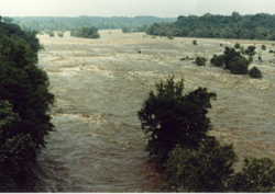 In
the spring of 1983 the river stayed in flood, high enough to swirl over
the paths along the river bank at Richmond and bar all but the bravest
kayackers, but lower than the official panic point. The granite monoliths
of the Falls became shadows playing under the smoothed, murky surface.
It was hard to find any dry vantage points, so I usually ended up perched
on the cover of a high sewage collector. But the show was worth it. The
river was busy rearranging itself, right before my eyes, dislodging logs,
rocks, and even little trees, and sending them to new homes. There was
no way I could predict what would sweep into sight next. I would not have
been surprised to see anything, though I was grateful not to see any of
the drowned cows or rooftops that bumped down the river in 1972.
In
the spring of 1983 the river stayed in flood, high enough to swirl over
the paths along the river bank at Richmond and bar all but the bravest
kayackers, but lower than the official panic point. The granite monoliths
of the Falls became shadows playing under the smoothed, murky surface.
It was hard to find any dry vantage points, so I usually ended up perched
on the cover of a high sewage collector. But the show was worth it. The
river was busy rearranging itself, right before my eyes, dislodging logs,
rocks, and even little trees, and sending them to new homes. There was
no way I could predict what would sweep into sight next. I would not have
been surprised to see anything, though I was grateful not to see any of
the drowned cows or rooftops that bumped down the river in 1972.