![]()
PAUSING FOR WAR
![]()
PAUSING FOR WAR
|
Several miles downstream from the Fall
Line, at the sharp bend where the river begins swinging into loops,
is a cliff of clay poised unsteadily above an eroding bank. The iron
cannon and wooden platform near its edge are barely visible from the
river, obscured by trees that have conquered the trenches and mounds
of soil.
I like to squat on the platform, playing
lookout and listening to the park tape that recreates the story and
sounds of battle. But no matter how intensely I look, there are no ghostly
Union invaders coming around the curls--unless barges of gravel and
foreign ships loaded with tobacco can count. Not many tourists join
me in these woods close by a busy interstate. But for years this spot--known
as Drewry's Bluff and now maintained by the National Park Service--marked
one of the few decisive victories and a turning point in what was called
the War Between the States. Here Virginians showed the world that they
knew how to exploit their river's curling ways and topography in war
as well as peace. They also demonstrated how apparent victories can
prove to be disguised defeat of a kind.
In the spring of 1862 it was clear to
federal strategists that Richmond was a keystone to victory. Other Southern
cities such as Memphis, Nashville, and New Orleans had been taken, but
now this metropolitan heart of the war machine and the capital of the
Confederacy must go. That seemed to pose little problem, since the Union
navy could back up troops on both the York and the James rivers, so
General McClellan shipped his army to Hampton Roads. But the entrance
to the James was blocked, not by ice this time but by iron.
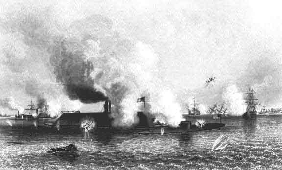
The steam frigate, CSS Virginia (formerly the USS Merrimack),
burned but inadequately destroyed by the Northern navy the previous spring,
had been raised by the Confederates, rebuilt, and armored with three inches
of iron and a four-foot iron beak. It was ugly, unwieldy with a 22-foot
draft, but a very effective guardian. On March 8, the Virginia
slowly steamed out of the Elizabeth River, heading for the two large wooden
warships, the USS Cumberland and the USS Congress, which
patrolled the mouth of the James and Hampton Roads. The Union guard was
down, and washing lines hung from the Cumberland. It was hard for
the Yankees to believe that a ship which, as Bruce Catton writes, "looked
like a derelict barn adrift on the tide, submerged to the eaves," could
pose a serious threat. All day hundreds of people watched from the shores
as the Federal fire bounced off the Virginia's iron plates and
both Union warships burned and sank.
Now the Monitor could proceed up the James with its squadron. It was no easy journey as the Monitor "inched its way through a narrow and intricate channel for thirty miles in constant fear of torpedoes and fire ships." Sharpshooters along the river picked off men from the decks, but the boats kept moving. At one of the last bends before the river straightens toward Richmond, the channel narrows and moves toward Drewry's Bluff, more than a hundred feet high and towering over the generally flat countryside with unobstructed view at least a mile in each direction. At Fort Darling, seven miles from Richmond, were perched the biggest Confederate guns, looming over a river channel blocked by pilings and sunken boats. Across the river on a lower hill, Chaffin's Bluff, was Fort Harrison; together they constituted a Gibraltar for Richmond. Against this union of nature and military strategy, even an ironclad could do little. The Federal ships never had a chance at victory in this position, especially since there was no way to raise the Monitor's turret guns high enough to hit the cliff fortifications. The inadequately armoured Galena took heavy fire and its iron works shattered and wounded many. The Union forces would not capture Richmond by traversing this well-defended river. General McClellan then moved over land toward the city, only to run into another obstacle course, presented this time by the swampy reaches of the Chickahominy, which joins the James below Jamestown. Without maps or understanding of how to deal with a river which has up to a mile of low land--swamp, marsh, and bog--on each side, McClellan had met an enemy he underrated. The bridges he ordered would do little good if storms raised the river, as they did. One bridge barely held, as did the Union lines, in the ensuing bloody Confederate attack at Seven Pines; the only winner seems to have been the river. The Union forces were still thwarted in their push to Richmond. Believing that he was greatly outnumbered, General McClellan was reluctant to press on, especially since rain kept falling. Soon General Lee, persistent though his force was small, did force McClellan to retreat back to the James below Richmond where his gunboats waited at Harrison's Landing (Berkeley). Though they could not attack the Federal fleet guarding the landing, the Confederates rejoiced over their victories. In August, Lincoln called McClellan and his army back to north Virginia, despite McClellan's protest that "It is here on the banks of the James that the fate of the Union should be decided." Then followed two devastating years of war which literally bled the South of men. But it would be spring of 1864 before Federal troops returned in force to the James to try to take Petersburg and Richmond. Meanwhile, Drewry's Bluff was reinforced and the Confederate Naval Academy established there. The curls of the river below the bluff were blocked with mines, most notably the electric torpedoes invented by Matthew Maury. Though the Union had the naval advantage, their ships entered the winding portion of the river at great risk. In 1863, the USS Commodore Barney was spared only because the charge under it was set off prematurely. The gunboat Commodore Jones was less fortunate at Deep Bottom a year later, for it was destroyed as it passed over a 2,000-pound electric torpedo. Angry soldiers from the accompanying ships captured the Confederate soldiers who set the charge and wisely tied one to the bow of the forward gunboat. As one historian recounts, "recognizing that the ship's fate would be his own," the man decided to inform and "thereby became a truly animated and effective, albeit unorthodox, minesweeper." Even with this information, a river reinforced with explosives was a formidable barrier, especially with its commanding bluff fort. Meanwhile, inhabitants of Richmond took advantage of their clear portion of the James. For fifty cents, they could take a steamer to the bluff and be entertained with music en route. On a single day in May 1863, 800 people came to watch the midshipmen in their maneuvers and gloat over their river bastion. The James also became the scene of mass baptisms as religious revivals swept the area. The continuing battles must have seemed very remote on these waters protected by the river's topography and man's ingenuity. Not everyone was free to take such pleasure
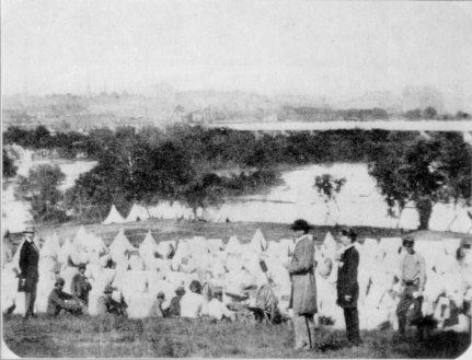
on the river, however. Libby Prison, high on Church Hill, was overflowing
with Union prisoners of war by June 1862, so the enlisted men were separated
out and sent to Belle Isle. In February 1864, the Federal forces tried another scheme to liberate the thousands of Union prisoners in Richmond. The one-legged Colonel Ulrich Dahlgren was to strike the city with 400 troopers from the west, moving along the unprotected south side of the river above the Fall Line, and then join the 3,000 cavalry soldiers led by General Kilpatrick. The plan was that Richmond forces would be engaged with Kilpatrick's troops, leaving the river open to Dahlgren's liberation. Nothing worked as planned, however, primarily because of the river. Dahlgren's men took advantage of their break behind enemy lines to destroy parts of the canal and railroads and freely plunder houses. But they had no boats to cross the James. A slave promised to guide them to a ford, but there could be no crossing since winter rain had swollen the waters. The guide was quickly hanged for the river's treachery. Dahlgren headed northeast, managing to cross the more docile Mattaponi, but by then Kilpatrick had been forced to withdraw his troops. When Confederate soldiers caught up with him, Dahlgren was shot, his body reportedly mutilated and then "lost." Meanwhile, General "Beast" Butler was planning to take Richmond from the river to the east. In May 1864, he brought an armada up the James, 30,000 soldiers aboard ten miles of ships led by five ironclads. Dropping a division at City Point, where the Appomattox joins the James, Butler landed at Bermuda Hundred at the entrance to the James River curls. Here he entrenched his troops behind a four-mile line stretching from a bend in the Appomattox to the southern point of the largest curl. A river assault was ruled out when the Commodore Jones exploded at Deep Bottom and the Shawneen sunk under gunfire that punctured its steam drum at Turkey Bend. Those curls were treacherous. A land attack on Drewry's Bluff was blocked by General Beauregard's forces and Butler's own indecision. After two weeks of struggle to capture the Bluff, Butler withdrew behind his line at Bermuda Hundred, where he was quite effectively "corked" by Beauregard. Surrounded by mined rivers, Butler had trapped himself. Unable to move, Butler decided to dig out by cutting a canal at Dutch Gap along the line of Dale's 1611 fortifications at the neck of Farrar's Island, thus bypassing the battery at Osborne's and allowing ships to cut off almost seven miles of the mine-laden river. On the first day of 1865, the powder charge which was to open the canal was set, but it misfired and gravel fell back into the ditch. Now exposed to direct fire, Butler's men could not finish the canal; Virginians thus gained most of a canal they had long wanted, and lost a curl to subsequent silting. The Union forces did hold the river up to City Point, so in June I864 General Grant moved the Army of the Potomac across the James. His engineers had to construct the longest pontoon bridge in history (2,200 feet) to carry miles of men, wagons, and horses below Westover. Sheridan wrapped up his Shenandoah Valley campaign by marching south to Scottsville, raiding the bustling town and demolishing miles of the canal upon which it depended. Because of flooding and insufficient pontoons, however, he could not cross the river to reinforce Grant at Petersburg since the Confederates had destroyed the only bridge, a covered bridge at Bent Creek. Richmond's downfall would not come from its river approaches.
The next day, Lincoln sailed up the James aboard the River Queen, maneuvering slowly through a narrow, cleared channel. As the boats kept grounding, Lincoln had to transfer to a barge to make his triumphant entry. He rode through the smoldering city, surrounded by wildly cheering emancipated slaves, but he spent the night in the safety of the Malvern, the flagship which had finally navigated the river successfully. Three days later, Lee surrendered to Grant at Appomattox, not far from the James, and within ten days Lincoln would be assassinated after he had sailed back to Washington on the Potomac. Although most of the sunken ships of war were later salvaged or removed from the channel, the silt of the James still hides its hulks. Occasionally there are those who campaign to raise the remainders of the old ironclads, not to clear the river or to reclaim the metal but to remember a simpler, more vulnerable style of battle when the river's topography was crucial to the outcome of a war. But the river hides its war scars well and the hulks lie deep. Just as hidden are most of the marks of the furious antebellum industrial activity along the Falls. The economic toll of a protracted war, the burning of Richmond along the river, and a slow reconstruction were particularly devastating to the riverside industry. People no longer had the spirit to do aggressive battle with the river; survival was crucial now.
Some of the antebellum structures were wiped out by the high floods of 1870 and 1877, just as the canal was, but most were simply torn down to make way for the next wave of prosperity that would come around the turn of the century. For a while, though, the river flowed seaward without being disturbed much by its neighbors, while the defeated South attended to its wounds.
|
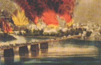 With
the Confederate defeat at Petersburg on April 2, 1865, the government
officials in Richmond realized that the city could not be defended and
must be evacuated. At City Point, President Lincoln heard the news and
prepared to steam up the river. In Richmond, government workers frantically
carried records to the Danville train station, while the only traffic
bridge, Mayo's, was opened for retreating military forces only. At midnight,
against the protests of the mayor, the departing troops destroyed nine
gunboats, including the Confederate ironclads, and set afire all major
warehouses and the powder magazine. Finally Mayo's bridge and both railroad
bridges were burned, and the city left to spreading flames, explosions,
and rioting. At 10:00 A.M. On April 3, the city surrendered and the
Federal troops began fighting the flames and building a pontoon bridge.
With
the Confederate defeat at Petersburg on April 2, 1865, the government
officials in Richmond realized that the city could not be defended and
must be evacuated. At City Point, President Lincoln heard the news and
prepared to steam up the river. In Richmond, government workers frantically
carried records to the Danville train station, while the only traffic
bridge, Mayo's, was opened for retreating military forces only. At midnight,
against the protests of the mayor, the departing troops destroyed nine
gunboats, including the Confederate ironclads, and set afire all major
warehouses and the powder magazine. Finally Mayo's bridge and both railroad
bridges were burned, and the city left to spreading flames, explosions,
and rioting. At 10:00 A.M. On April 3, the city surrendered and the
Federal troops began fighting the flames and building a pontoon bridge.
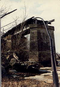 But
with a bit of river bank sleuthing, there are still reminders of those
days to be found. A rebuilt Bosher Dam still channels water down several
miles of the existing James River Canal, past stone buttresses that
were once locks. At the other end of the Falls, the low Manchester dam
still detours water into the shorter Manchester Canal. There is one
high set of locks, leading to the lower portion of the canal where ships
were once built. No canal serves boats or industry now, and there are
no more shipyards at the head of the tidewater. Belle Isle reveals nothing
about its infamous tenure as a prison camp, and its northern cliffs
are reduced to a deep quarry pond. The ruins of Tredegar Iron Works
are slowly being restored, and some rocky dams and channels bear testimony
of mills that once straddled their races.
But
with a bit of river bank sleuthing, there are still reminders of those
days to be found. A rebuilt Bosher Dam still channels water down several
miles of the existing James River Canal, past stone buttresses that
were once locks. At the other end of the Falls, the low Manchester dam
still detours water into the shorter Manchester Canal. There is one
high set of locks, leading to the lower portion of the canal where ships
were once built. No canal serves boats or industry now, and there are
no more shipyards at the head of the tidewater. Belle Isle reveals nothing
about its infamous tenure as a prison camp, and its northern cliffs
are reduced to a deep quarry pond. The ruins of Tredegar Iron Works
are slowly being restored, and some rocky dams and channels bear testimony
of mills that once straddled their races.