|
The ideal way to float the upper James,
according to my "river rat" friends, is in a tractor-tire innertube,
either alone and soundlessly or with a group of boisterous friends,
pulling extra tubes with coolers tied inside. That is, it is ideal for
those who do not object to their skin being broiled on one side and
shriveled and bruised on the other. Evidently there are many who are
willing to trade their comfort for the privilege of knowing the river
so intimately. On almost any summer day when the water is low and clear,
the young at heart can be found bobbing through sections of riffles
between Buchanan and the Fall Line. In the rapids that foot each of
the favored stretches are their more daring compatriots, testing themselves
in whitewater canoes and kayaks against the river's more challenging
obstacles at Balcony Falls and in the heart of Richmond.
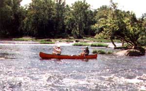
However, I prefer the meditative company
of the lazy canoe floaters, paddling to break the monotony of flat water
or to dodge rocks and islands, but most of the time simply dragging
an oar as a rudder and letting the river current have its way. I also
feel akin to the fishing floaters I pass who are absorbed in casting
for the wary smallmouth bass. For contemplative canoeists like us, floating
means there is no where to go, and no when either, for the space of
a day or a weekend.
Many find that the upper reaches of the
James, where the shallower water courses over the limestone laid by
prehistoric seas in the shadow of the Blue Ridge Mountains, offer the
best canoeing or tubing, especially in the brilliantly tinged autumn.
Much of the charm is that so few people trek over winding mountain roads
to this relatively secluded valley far from the highways. Even fishermen
prefer to go for the trout in upstream tributaries or for the smallmouth
bass downstream, leaving the river free for the select folks who simply
enjoy it.
The more than fifty miles of piedmont
river between Scottsville and Richmond include the stretches that keep
drawing me, however. Here are gentle curves, multicolored rocks sometimes
rising above the water, and islands of all descriptions. This is a world
in motion, never the same. Its constant variations in water level and
clarity combine end- lessly with the changing reflections of light,
wind, rain, and season. Even the islands keep adjusting in shape from
year to year, expanding on one end as the other yields to the currents,
and some dividing or disappearing after high water times. This shifting
land will not be owned, regardless of deeds lying in county courthouses,
except temporarily by campers with boats or deer giving birth in the
spring, and the ever-present kingfisher who so raucously claims his
territory.
I do not linger long here, for it is the
river which takes shape over hidden rocks that keeps luring me downstream.
The fluid patterning and sounds of the water's surface make complex
music. The underlying rhythms are smooth and swift, with harmonic changes
rung by fluctuating water levels. The melody comes from below, where
the uneven contours of the river bed make the whirls, eddies, waves,
holes, and smooth or rippled textures. Counterpoint is rung on the surface
with the instruments of wind, rain, and the dipping and skating insects,
punctuated by the percussive leaps of the frogs and the fish. Once,
as I paddled in a rainstorm, jumping with each distant thunder clap,
I heard under the pounding raindrops a low steady hum which penetrated
and calmed my shivering body. I can still hear this hum of the river's
"valv'd voice" in my dreams, and I wonder if it might be the same soul
that Walt Whitman invited into his body in "Song of Myself" Perhaps,
for me, it is.
With practice, I have learned to read
the river, to imagine with some accuracy what lies beneath the designs
spreading over its surface. This is a skill necessary for running whitewater
rapids or finding the fish hovering in the rocks' eddies, but I use
it more to anticipate the next musical phrase of the river. There are
also times when I have learned to suppress this knowledge, to give in
for a while to the hypnotic spell of the watery world, my soul detaching
from time and responsibilities. It is then that I understand myself
what Thoreau meant about drifting: "I almost cease to live and begin
to be. A boatman stretched on the deck of his craft and dallying with
the noon would be as apt an emblem of eternity for me as the serpent
with his tail in his mouth. I am never so prone to lose my identity.
I am dissolved in the haze." During these timeless moments I succumb
to the spell of entropy, caught in the fluid time which melts trees
and rocks. But I must not forget that the music of rocks and currents
is the same siren song which lured mariners to their doom.
Actually I am not in much danger, for
I am never alone in my canoe. My favorite partner, my daughter, is a
silent paddler who lets me roam mentally but keeps me pointed safely.
Few sounds of the twentieth century distract us, only the faint drone
of a plane, a tractor, or a train, all easily drowned by riffle splashes.
The trees lining the river block any view of house or barn above the
floodplain, and the cows browsing beneath are not intrusive. So I let
myself free to float through river time.
The land once claimed by the Huguenots,
and the Monacans before them, today lies as mostly pasture behind the
trees, but these folk seem to have passed on as effortlessly as the
river flows. They left no monuments, not even houses, standing along
this river, only their bones and other cast off things. Romance and
death seem to cohabit easily in this world, especially near a spot called
Maiden's Adventure, or Maidens. Here, it is told, a maiden drowned trying
to ford the river to aid her lover, set on by scalping Indians as he
picked flowers for her. Only the name remains, although the same wild
flower probably still blooms each spring. The Monacans did not even
leave a romantic story to history before they moved up the river, only
the hearthstones and axes exposed by each flood.
As we float past anglers trying to lure
smallmouth bass away from their comfortable niches, I try to visualize
those restless anadromous species which once reproduced in this clear
water. For centuries people above the Falls depended on the annual spring
and fall runs of shad, herring, striped bass, and even sturgeon into
fresh water, catching the fish as far upstream as Lynchburg. The Indians
took full advantage of these seasonal migrations, adjusting the rhythm
of their lives to those of the fish.
Later piedmont settlers were often sustained
by the runs as they pushed upstream to new lands. At one time, enough
fish were harvested above the Fall Line to provide a six-months' supply
of protein for those who had the salt. Little did they realize that
they were choosing between fish and navigation when a fish dam was rebuilt
just above the Fall Line some time after 1780 and before 1823 to divert
water into a canal so boats might reach Richmond more easily. Bosher
Dam abruptly chopped the fish migration in half, and the shad and herring
were restricted to the rocky Falls for their spawning grounds, except
for the few who later braved the canal locks. For almost a century,
until restocking was begun, there were few fish of any kind to be caught
above Bosher Dam. Yet I can find no record of anyone complaining about
the drastic impact of the dam; perhaps no one made the connection.
These musings stop abruptly. Bosher Dam,
now ten feet high, blocks our progress just as surely as it did that
of the shad and the herring. Our float on the river must halt but my
float through time continues, in the more sedate world of libraries.
The books, though, offer few clues about what the James looked like
above the Fall Line before people started reshaping the river and its
basin. Those who came to settle refrained from nonessential descriptions
and quickly set to their practical activities. But there were some witnesses
who did record their impressions who can help me recreate today what
the Falls area, at least, must have looked and sounded like at the end
of the eighteenth century.
Just before the Revolution, as the new
city of Richmond was organizing itself, another John Smyth, John F.
D. Smyth to be exact, noted that "the river's cascade hardly felt the
restraints of man." He described a "vast current of water" which "rushes
down, with an astonishing roar that is heard for many miles distance"
between "hills of a great height" which abound "with prodigious rocks
and large stones as well as trees." Houses built on these hills had
a "wild, grand, and most elegant perspective."
A few years later, a Hessian surgeon named
Dr. Johann David Schoepf designated the James as "one of the greatest
and most beautiful of American streams." He too remarked on the "foaming
uproar," claiming it could be heard at night "not only throughout the
town but, before the wind, for several miles around." The scope of the
sound of the rapids' roar through the city has contracted today, engulfed
by modern noise levels and dampened by construction perhaps. Or is it
that no one listens? Be that as it may, the granite sculpture lining
the bottom and sides of the river for miles here is not so different
two centuries later, though it is more exposed in places because of
dams and water use.
For a long time, observers speculated
that only Indian hands could have scooped out the hundreds of potholes,
probably to grind corn, for they assumed that human intelligence was
required to make such symmetrical depressions. Very likely there are
still those who would like to dispute the geological explanation, for
there.is something a bit fearful about the kind of force capable of
this carving. Or perhaps it is hard to conceive that the regularly shaped
holes were not made mechanically for some legitimate human use.
The person most identified with both the
art and geology of the Falls at the time is the architect
Benjamin Latrobe. He came to Richmond from Britain in the closing
years of the eighteenth century to design a penitentiary high above
the river. His first impression was that Richmond resembled its namesake
on the Thames, except for "the want of finish and neatness in the American
landscape." Here was "the grandeur of Nature" as opposed to the "perfection
of cultivation." The rugged beauty of the rocks particularly intrigued
him and he sketched and wrote extensively in his journal, exploring
explanations for their shape and geologic origins. But his scientific
inquiries did not restrict his aesthetic appreciation. The juxtaposition
of rushing water and rock took center stage in watercolor paintings
he did of the region.
Yet Latrobe was just as fascinated by
the possibility of river improvements that would help eliminate the
wild grandeur he admired. He praised an extensive wooden and stone weir
constructed at the lower end of the Falls to direct water into a canal
as well as stop the shad and herring on their spring run. He found it
"boldly conceived and admirably executed ... likely to last for many
years, if not for centuries." His only complaint about the canals being
dug around the Falls was that his own architectural talents were being
ignored. Though he took certain pride in not being a Virginian, his
ability to mix aesthetic delight in the wild river with practical considerations
about taming the James was typical of the contradictory nineteenth-century
attitudes about the river expressed by native Virginians.
Latrobe was particularly taken with an
80-acre island in the Falls, the one that William Byrd called Broad
Rock, which was then owned by Bushrod Washington and called Washington's
Island. Latrobe's enchantment with this island has bequeathed us a detailed
portrait of its untamed beauty. Evidently Byrd's attempts to find iron
ore there had been well erased by then. According to Latrobe's journal,
the island seemed to hang precariously in the midst of roaring cascades:
Soon, though, Latrobe purchased the island
to begin his own kind of domestication. He intended, as he wrote a friend,
"to live there ... shutting myself up in my island to devote my hours
to litterature, agriculture, friendship, and the education of my children."
Either the river no longer appeared so wildly furious to him now, or
else his boredom and loneliness had transformed the island into a likely
agrarian retreat. Then an invitation arrived from Philadelphia to design
the city waterworks, and he left the island for the Virginians to develop.
And develop it they did, starting with
Latrobe's notion of farming the flat land. Soon that bit of land became
more profitable as a race track. Then a small nail factory was built,
with a wooden dam beside it to trap water for power. By 1832 this factory
had become the large Old Dominion Iron and Steel Works, sharing the
east end of the island with a snuff factory. On the west end, that "immense
Pile of Granite" was soon reduced, quarried to pave the streets of Richmond.
The hill behind it was covered with company houses and the requisite
church and cemetery.
The history of this island reflects the
early history of the entire lower Falls area. No longer an insular wilderness
paradise, it acquired a new name that still stands: Belle Isle. Ironically,
the name is said to be a corruption of Bell's Isle, named after a Scottish
tenant. The engineer in Latrobe might very likely have approved of the
island's fate, but surely the artist/scientist who had investigated
geological history and been inspired by the Falls to paint and write
a small book on landscape drawing would have been dismayed. Once tamed
to serve human purposes, this island proved to be no paradisiacal retreat.
The reshaping of Belle Isle was gentle
in comparison with what was happening to the high ground north of the
river at the Fall Line early in the nineteenth century. Byrd, Latrobe,
and others describe a multitude of sharp hills--actually many more than
the seven that the city liked to advertise--which had been cut and eroded
by springs and streams, especially the large Shockoe Creek in the middle
of the town which emptied into the eastern end of the Falls. Samuel
Mordecai, aged when he wrote Richmond in By-gone Days, recalled
for his readers in 1860 the contours of that world, with its many hills,
gullies, ravines, and swamps. As he wrote, "the city was all hills,
valley and deep ravines, and had a most forbidding aspect."
Since much of the sloping land could not
be easily developed, there were a number of gardens and park squares
scattered about, complete with springs and ponds, frogs, and children.
Many springs were left undisturbed since they served as a source of
domestic water. Some of the gardens, particularly those bordering the
river and later the canal, were minor commercial ventures on the European
model where people strolled for a small fee. As Mordecai reminisced,
there were many "rural and romantic spots," no longer wild but cultivated
to retain their natural charm. However, the pressures of a growing population,
especially as the river and canal trade flourished, meant that the luxury
of even the cultivated gardens had to go, and the land must be leveled
for development. By 1860, Mordecai noted that "the original and the
present surface of the city may be compared to the contrast of the waves
in a storm, and their subsidence during the calm."
Actually it is most fitting that our lazy
float downstream should be blocked by Bosher Dam. It rises as the boundary
between two very different worlds, as much today as 3,000 years ago.
Upstream is a world where time and men have moved slowly, almost stopping
for the past century, and left few marks on the river or its surrounding
land. The other world of the Fall Line has been drastically transformed,
dating to the days when the dam was raised high enough to remold the
river, and only a heroic effort of infusing historical accounts with
imagination can begin to restore it. There is little peaceful floating
through this world, either through time or the Falls, only the rambunctious
interplay of the energies of people and the river they had claimed.
|
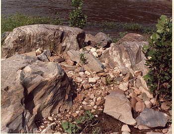 My
favorite camping spot is a sandy sculpture garden south of the Hardware
River junction, which can be reached now only by canoe. Here, in eons
past, mineral-enriched rock of varying hardness was melted and literally
poured through the granite. Then the water began persistently carving
out all the weaker points. The result is art, unique sculpture of many
shapes and textures streaked in red, yellow, and blue, which is visible
when the water drops its veil. Thoreau's words come to my mind, for
it is "as if, by force of example and sympathy after so many lessons,
the rocks, the hardest material, had been endeavoring to whirl or flow
into the forms of the most fluid." Each stone seems almost as liquid
as the river which has shaped it, like flux caught in a moment of solidity.
My
favorite camping spot is a sandy sculpture garden south of the Hardware
River junction, which can be reached now only by canoe. Here, in eons
past, mineral-enriched rock of varying hardness was melted and literally
poured through the granite. Then the water began persistently carving
out all the weaker points. The result is art, unique sculpture of many
shapes and textures streaked in red, yellow, and blue, which is visible
when the water drops its veil. Thoreau's words come to my mind, for
it is "as if, by force of example and sympathy after so many lessons,
the rocks, the hardest material, had been endeavoring to whirl or flow
into the forms of the most fluid." Each stone seems almost as liquid
as the river which has shaped it, like flux caught in a moment of solidity.
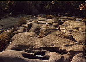 The
rocks of the Falls are huge chunks of granite, some incorporating the
harder and darker xenoliths or "foreign stone," undulating across the
river bed, dipping and breaking along fault lines where the water has
worn most persistently. Most remarkable are the many deep potholes formed
by harder rocks from upstream trapped in a crack and spun by the river.
The
rocks of the Falls are huge chunks of granite, some incorporating the
harder and darker xenoliths or "foreign stone," undulating across the
river bed, dipping and breaking along fault lines where the water has
worn most persistently. Most remarkable are the many deep potholes formed
by harder rocks from upstream trapped in a crack and spun by the river.