| For
months in 1983, the water gates were clamped shut, holding back the river
to expose several miles of an earthen ditch, remnant of a dream called the
James River and Kanawha Canal. I picked my way among the half-buried
sewer pipes and earthmoving machines, following in the digger's path, to
look for discarded treasures--once junk--of more than a century ago. It
was a quiet Sunday, with city sounds muted by cliffs on one side and marshy
river bank on the other. With some imagination, I heard instead the creaking
of iron hinges on the locks, cries inciting mules on the towpath, and the
laughing echoes of excursioners floating up to Lynchburg. My concentration
was interrupted by the imperious blast of a train whistle. I backed into
a quarried niche in the cliff, perhaps carved out long ago by a rented slave,
to retreat from the cloud of dust flying off an interminable train carrying
coal from the mountains to the sea. Now the gates are opened and the detoured
flood rushes through again, going nowhere except back to the river, a truncated
reminder of the American hope of conquering a frontier wilderness by taming
its rivers.
Even before the American Revolution, George Washington started preaching the advantages of building canals to lead the young country westward. In theory, it seemed a simple enough matter to bypass the river where it raised navigational barriers, to borrow its water but not its swift currents to flow through a deep ditch with locks where mules could provide the power. Then the river's water would provide a proper highway, not so subject to the moods of weather. The same arguments were soon to be heard all over the country, and they were to be bolstered by the easy construction and quick profits of the Erie Canal. However, when Washington took his proposal for two canals crossing the Fall Line, one of the Potomac and one on the James, to the House of Burgesses in 1774, it was rejected--it would cost too much money and it did not appear practical enough. Besides, it seemed to be a matter for private investors, especially since the state was not inclined to negotiate the resulting political squabble between northern and central Virginia canal advocates. But once independence was achieved, the idea of "river improvements" became more alluring and the canal fever spread. Americans were ready to turn their backs on England and move westward; a people who had challenged one world power and succeeded were not to be intimidated by the obstacles of a mere river. The projected canal appealed to the westering vision by offering a stronger political and economic union with the west and a foothold on possibilities for America to fulfill its "manifest destiny" of stretching to the Pacific. But Virginians were more impressed by the opportunities the canal would open for making money at home, thus keeping restless workers from ranging to the richer lands of the west. James Madison, writing to Thomas Jefferson about Washington's "patronage of works for the extensive and lasting improvement of natural advantages," listed the possible benefits for Virginia. Such works "will double the value of half the lands within the commonwealth, will extend its commerce, link with its interests those of the western states, and lessen the emigration of its citizens by enhancing the profitableness of situation which they now desert in search of better." What started out to be a fairly modest plan to circumvent the Falls soon became part of Washington's dream of "The Great Central American Water Line." With canals and highways, where necessary, to connect the James to the Greenbrier, the New, and the Great Kanawha rivers, linkage could then be made all the way to the Rocky Mountains, following the Ohio, Mississippi, and the Kansas rivers. Though the full project never materialized, it does show the kind of grandiose schemes Americans were inspired by their rivers to concoct. Again the myth of the river obscured the reality, for no one dreamed of the cost and difficulties that were to arise in the next fifty years. The James River Company was incorporated in 1785 and within a decade two canals had been built around sections of the Falls. Although they did not yet connect with the tidewater river, they showed significant profits after full tolls were put on in 1806. Many of the rocks were cleared from the river above Richmond and wing dams were constructed which would channel the current in shallow stretches. This allowed the passage from Lynchburg to Richmond of bateaux, each powered by an expert steersman to shoot the rapids and two strong polemen to defy the current; by 1816 some could even make it through the treacherous Balcony Falls from Buchanan by shooting rapids and dodging rocks. The trip was often risky at both high and low waters, and the James is often one or the other, but the profits to be made from selling tobacco, iron ore, and furs in Richmond were convincing.
A bateau ride was no trip for passengers, however, and there were many on the lower James who wished to visit friends and family who had moved west. The consensus was that only a full canal could provide a dependable, calm waterway. But the longstanding rivalry emerged over which bank should have the canal. Southside residents justly feared that profits would remain only along canal borders. But no less a speaker than Patrick Henry (ironically, hired by a Manchester merchant who feared competition) opposed them in the General Assembly. For years they petitioned for the "healthy competition" of a Manchester canal extension, but they could never buck the power of the north, and so had to be content with their short canal at the base of the Falls. After many lawsuits were filed claiming that the James River Company, then the biggest business corporation in Virginia, cared only for its dividends and so neglected necessary repairs and improvements, in 1820 the state purchased the company's charter. Unwilling to antagonize the powerful stockholders in the corporation, the state promised to pay a 12% dividend rate each year until 1832, and 15% "forever afterwards." (Washington and Lee University long received $3,000 a year from the state for the hundred shares of stock willed it by George Washington, even after the canal was defunct.) Taxpayers were no happier with results of the state's supervision either, once they saw how much money was required to build and improve the half-finished canal. Now that it had become a political matter, sections of the state which did not benefit opposed the canal loudly. The divided legislature eventually refused funds, so in 1835 it was time for the canal to go back to private ownership. American shave rarely been satisfied with their business arrangements: under private ownership, the canal made too much profit, but state ownership meant that too many tax dollars hd to be spent. After three years of raising funds, the James River and Kanawha Company was in business. By 1840, the canal, at a safe remove from most of the river and now accommodating the mule-pulled packet boats, had been completed to Lynchburg, and in 1851 all 197 miles of canal (with 37 miles of slackwater river) were completed to Buchanan. The canal, forty to fifty feet wide and five feet deep, had proved to be a massive venture, requiring 90 locks lifting 728 feet, 23 feeder dams, 12 aqueducts, 198 culverts, and 135 bridges. Next on the list was a 1,900-foot tunnel which would bore through the mountains west of Buchanan, but that was abandoned after 1.5 million dollars were spent. There were also unexpected physical problems with the James River Canal. Design and management of the construction were haphazard and amateur, as verified by engineer-architect Benjamin Latrobe, who observed in 1795 that the canal "is neither judiciously, nor ornamentally managed, and there are several most gross blunders in its execution." Construction proved quite hazardous, with only black powder and hand labor to clear the way. The toll in human life was high, but the numbers are not recorded, for they were the uncounted lives of rented slaves and later, Irish immigrants. Eventually at least 11 million dollars were spent just on construction of the canal from Richmond to Buchanan, fifty miles beyond Lynchburg and the Blue Ridge. The price for improving the river with a canal had proved far greater than anyone had imagined. Taxpayers were also surprised to discover that the temperamental river made maintenance an ongoing and expensive process. The clay lining the canal often leaked and eroded the bank facing the river, called the berm. Floods washed out banks, locks, and towpath, and the usual summer droughts literally grounded the boats, necessitating the building of dams to channel more water into the canal. And so the fish met even more barriers. Each disaster fueled the "progressive" argument for replacing the canal with the railroad. While the country bickered over its division into North and South in the 1850s, many people delighted in cruising the canal from east to west in packet boats seventy to eighty feet long and eleven feet wide. For a little over five dollars they could make the 33-hour journey from Richmond to Lynchburg, stealing through forests and farmland. Quarters were close, especially at night, but as George W. Bagby recalled, daytime lounging on the deck, "where there was a great deal of interest, and naught to mar the happiness," was particularly enhanced for gentlemen by the freedom to "spit plumb into the water" at will, reinforced by juleps from the "vigorous and healthy" bar below. Ladies also enjoyed strolling on the towpath between locks as a welcomed antidote from cramped "limbs." However, even at the height of activity, there were only six passenger packet boats operating. The profit lay in transporting goods, not tourists. Over 200 freight barges were in constant use, carrying lumber and agricultural products east, including plenty of corn whiskey from the mountains, and ferrying general goods and staples west. Barge crews would even tie up to help a farmer finish his harvesting so they could fill up with wheat for mills at the Falls. In 1860, the peak year, almost a quarter of a million tons of goods were barged east and west. Even racial differences counted for little when the common enemy was the fury of the river. The ancient rock bounding the river where it passed through the Blue Ridge Mountains at Balcony Falls had proved impenetrable, so canal boats had to pass through so-called slack water. In 1854, a boat with fifty people aboard was inching up the towline in flooding waters when the line broke and the boat was hurled over a dam and into the rapids, where it hung tentatively on a rock. Three slaves and two white men came to the rescue, fighting the rapids to tow the passengers ashore, but Frank Padgett, the slave who led the successful rescue, and another slave were drowned. The boat's captain later erected a granite memorial to Padgett's bravery, which still stands. Any kinds of union promoted by the canal could not compete with the increasing disunion of the nation. The Civil War began the canal's doom, for all work and improvements stopped abruptly. In 1865, General Sheridan and his troops wrecked the waterway locks and banks for ninety miles above the Falls, and the great Richmond fire burned the central offices. After the war, federal funds for canal repair were not available for the defeated state, in spite of enthusiasm for rebuilding form the midwest as well as a French company which owned land in western Virginia. A flood in 1877 finished off the half-repaired canal for good. Few complained when the railroad purchased the canal to use its towpath for the railroad bed. No one cared about navigating up the river any more, for the romance of the railroad was not ascendant. In the summer of 1983, however, it was a railroad conglomerate, including the railroad still running on the towpath, which was responsible for literally unearthing memories of the days of the canal's prosperity. In the heart of Richmond at the foot of Capitol Hill, the CSX Corporation began digging for the foundation of a skyscraper to overlook the James, right o the former site of the great canal turning basin. Here was once the heart of the canal system, where barges exchanged goods with ocean-going ships, but it was filled long ago to become valuable downtown property. CSX, realistically motivated more by public relations strategy than by guilt over the railroad's role in the canal's demise, halted construction when bulldozers began uncovering mud-preserved canal boats. Time and money were short, but scores of people descended on the site with buckets and shovels when the state archaeologist called for help through the media. Soon they found over thirty boats, including three in good enough condition to attempt salvaging. They also founds piles of 1850-vintage junk--shoes, lamps, tools, garbage--whatever was either thrown out or had been sunk the in the basin. In a few weeks, the bulldozers had to start up, leaving more treasures in the mud, but for a while the city shared a trip into the past. The boats, including the oldest canal boat ever recovered, lie in a restored segment of the canal awaiting funds for preservation and exhibition. But for historically minded Virginians--and they are legion--the canal is still not entirely dead. It lives in a more tangible but less obvious fashion in the pattern of settlement existing above the Fall Line. The canal itself is virtually invisible, little more than a shallow ditch, long claimed by silt and weeds. But its effects linger. Its path is marked by the towns on the north side, some with fine houses and marketplaces still standing, which now struggle to survive, too far from the interstate highways. The south bank of the river is largely inaccessible, for its rolling hills covered by farmland and forests lack even a road to parallel the curving river. Thus the canal reinforced the sort of cultural division begun by the tidewater river. The upper James, though, shows few marks of its busy past today. Since development became centered north of the canal, generally on hills safely above most flood levels and not on the river itself, its banks and floodplain are relatively free of the kind of land improvements of business and industry common on most rivers. Even houses are rarely visible from the river between Lynchburg and the Fall Line, and upstream between Buchanan and Balcony Falls. A few vestiges of the earliest river improvements, such as wing dams and ditches that fed the canal, remain, but one must look sharply to see them. Thanks to its canal heritage, the river runs freely and rather clearly in these stretches, no more a highway but a one-way trail reserved for canoeists seeking an easy float through a predominantly natural riverscape.
|
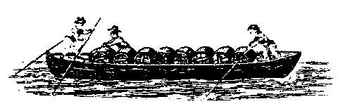 For
a while only freight could make the journey between Lynchburg and Richmond--seven
days down and ten days back. To pole these unwieldy craft was a choice
occupation for Negro slaves, in spite of the physical rigors. It was hard
not to feel free on the river, away from an overseer, pitting brain and
muscle against an indifferent adversary, the changing and rocky river.
The bateaux traveled in groups of three; two were usually sold to the
lumber-hungry Richmonders, then the polesmen spelled each other back up
the river in the remaining craft. At one time, five hundred bateaux were
challenging the river with their profitable loads.
For
a while only freight could make the journey between Lynchburg and Richmond--seven
days down and ten days back. To pole these unwieldy craft was a choice
occupation for Negro slaves, in spite of the physical rigors. It was hard
not to feel free on the river, away from an overseer, pitting brain and
muscle against an indifferent adversary, the changing and rocky river.
The bateaux traveled in groups of three; two were usually sold to the
lumber-hungry Richmonders, then the polesmen spelled each other back up
the river in the remaining craft. At one time, five hundred bateaux were
challenging the river with their profitable loads.