![]()
![]()
|
The story of the river begins in the hieroglyphs
of rocks unearthed and translated by geologists. The image they offer
is dim and sporadic, covering the 600 million years that this river
has known a restless bed, one which has plunged it beneath seas, carved
out broad floodplains, and then thrust it into angular new paths. A
description of this vast history, then, must be a moving picture, a
kind of three-dimensioned holograph which can project through both time
and space.
The river came to be in a world man would
never recognize, one of unbelievable heat and stress and colossal movements,
one with little or no vegetation to hold the slopes, only water, wind,
and gravity forcing furious erosion. During unimaginable reaches of
time, pressed by the weight of miles-deep sediment from the erosion
of the bare hills, the earth's crust is believed to have sunk, creating
a massive trough filled by a shallow sea which stretched west through
what is now named Ohio, south to Alabama, and north through New England,
drowning the headwaters of the ancient James.
As the continental plate shifted, the
earth continued to flex, compressing and faulting and lifting that sediment
more than 250 million years ago into what may have been the highest
mountain range on earth. And the waters of the river kept flowing, turning
the lofty mountains green and then, bit by bit, transforming them into
fertile plains closer to sea level. Again the earth heaved, thrusting
up new mountains, again "rejuvenating" its streams by forcing them between
steep banks. Still the river kept on flowing, licking at the feet of
the shifting hills, cutting its gorges and cascades.
The rock east of the mountains partook
of the neighboring upheaval. Heat, movement of the earth, and igneous
invasions literally metamorphosed the rock. Like the river above it
the rock moved and merged, but in the slowest of tempos. For fifty miles
it even detoured the southeasterly river north along insistent faults
in the underlying marble, asserting its mastery over the knifing waters.
At the edge of the Piedmont Plain is the
Fall Line, a band of granite which formed more than 185 million years
ago and now is the base of several cities along the eastern coast of
the United States. Here the river drops more than one hundred feet over
eight rocky miles, though never suddenly, into the deep sandy sediment
beginning below Richmond where three-foot tides still sweep over what
were once the shores of prehistoric seas.
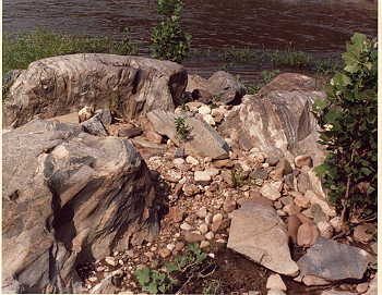
Where there is a persistent river, few
rocks prove solid enough to withstand it. Even the tough granite at
the Fall Line is pocked with holes where smaller, harder, old rocks
from upstream have been the tools of tiny whirlpools wearing at fault
and joint lines in the rock. During summer droughts, this worn backbone
of the East Coast sometimes lies almost fully exposed under the crossing
shadows of Richmond's bridges. Such apparent vulnerability is misleading,
for here reared a barrier, not just to the first colonists, but to all
people who used the watery highway.
Fine tuning that moving holograph again,
with a million years converted into minutes, shows the ocean rushing
to and even beyond the Fall Line, then ebbing like a great tide, stranding
whales in area valleys not once but several times, as recently as 40
million years ago. Add a touch of imagination, and the air at Richmond
begins to smell of salt; the roar of the rapids becomes submerged by
the boom of the surf. Just beyond the shore might be heard the lumbering
of dinosaurs through swamps south of the river, trampling the undergrowth
into high quality coal and even a diamond or two.
The ocean has receded now, drowning only
a hundred miles of river that persist to the edge of the continental
shelf. But the Chesapeake Bay still extends its salty tides to mix with
the fresh water over the growing bed of sediment in this Coastal Plain
and the part of the river called tidewater. Not subjected to the stress
of being rejuvenated by uplifting land, the old river can finally relax
here and be- come sluggish, forming great gaps or bends pierced by impatient
floods and men up to the point where large rivers, the Appomattox and
the Chickahominy, force the river into line again. The placid appearance
and tawny color mask a wealth of life adapted to either fresh or salt
water or both, and cover the graveyards of the "royal fish," whales
and sturgeon.
Below the Fall Line the river keeps bearing
down its slope, forming a tidewater estuary full of marshes and swamps.
The James then takes its place as the southernmost of many rivers--the
British-named York and the Indian-named Rappahannock, Piankatank, Potomac,
Patuxent, Patapsco, Choptank, Susquehanna, and the Sassafras--which
mingle their waters in the Bay before they rush through the capes to
the ocean.
Somewhere and at some time, a similar
estuary where salt and fresh water mix was the birthplace of certain
ocean fish who adapted to the fresh water and kept moving upstream.
During a drought, these fish found themselves stranded on the margins
of swamps and ponds. Eventually the survivors developed primitive lungs,
for at that time and place there was far more of the precious oxygen
in the air than in the water. In time the kin of those adventurous fish
learned to live with the alien element of air and so left the waters
of their birth. But they carried the river within them. As Loren
Eiseley has written, "As for men, those myriad little detached ponds
with their own swarming corpuscular life, what were they but a way that
water has of going about beyond the reach of rivers!"
With the coming of man and his self-conscious
brain, that river which had flowed cleanly and insistently for eons
was no longer to be defined solely by its relationship with the soil
and rock. Now it would be defined and thus changed by the eyes and actions
of the children it had once nourished. The river continues to sustain
these human beings who settle and roam its banks and play in its water.
Though they can chant a litany of practical reasons why they are often
drawn to the river, perhaps none is as strong as the deep compulsion
to return home, to touch base once again. Perhaps like me, they see
in the river images of entropy and renewal, and above all, themselves.
They too may want to know not only the river, but the life that is the
river that flows through us all.
|
 The
James officially commences with the marrying of two headwater streams
at a place called Iron Gate. Here the cool, placid Cowpasture, receiver
of the waters of the Bullpasture and the Calfpasture, meanders through
rich farmland, then joins the hot, energetic Jackson, which has been
fed by a multitude of warm mineral springs and tumbled down a rocky
pass. During the eighteenth century the river carried the name of both
a king, James, and a queen, Anne, who insisted that the upper James
above the Rivanna be renamed the Fluvanna (or the "river Anna"). Though
all these names have been pasted on by man, they seem to acknowledge
the reconciling of opposing forces that keep giving birth to the river.
But when the unnamed river first emerged, it had to reconcile far fiercer
opponents.
The
James officially commences with the marrying of two headwater streams
at a place called Iron Gate. Here the cool, placid Cowpasture, receiver
of the waters of the Bullpasture and the Calfpasture, meanders through
rich farmland, then joins the hot, energetic Jackson, which has been
fed by a multitude of warm mineral springs and tumbled down a rocky
pass. During the eighteenth century the river carried the name of both
a king, James, and a queen, Anne, who insisted that the upper James
above the Rivanna be renamed the Fluvanna (or the "river Anna"). Though
all these names have been pasted on by man, they seem to acknowledge
the reconciling of opposing forces that keep giving birth to the river.
But when the unnamed river first emerged, it had to reconcile far fiercer
opponents.
 Though
this metamorphic heart of a metamorphic river is called the Piedmont
Plain, it is more accurately a plane, repeatedly jutting upwards, repeatedly
forcing the river out of its natural aging tendency to wander into wide
meanders, giving it instead a sharper, deeper, and more directed second
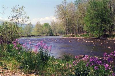
childhood. The piedmont river flows through its wide and ancient floodplain,
collecting islands that fish-trapping Indians were to settle and sculpting
the metamorphic rock with its red, blue, and yellow mineral streaks.
Though
this metamorphic heart of a metamorphic river is called the Piedmont
Plain, it is more accurately a plane, repeatedly jutting upwards, repeatedly
forcing the river out of its natural aging tendency to wander into wide
meanders, giving it instead a sharper, deeper, and more directed second
childhood. The piedmont river flows through its wide and ancient floodplain,
collecting islands that fish-trapping Indians were to settle and sculpting
the metamorphic rock with its red, blue, and yellow mineral streaks.